Altimeter
The following figure shows the configuration menu for an external altimeter like LIDAR, Sonar, etc.
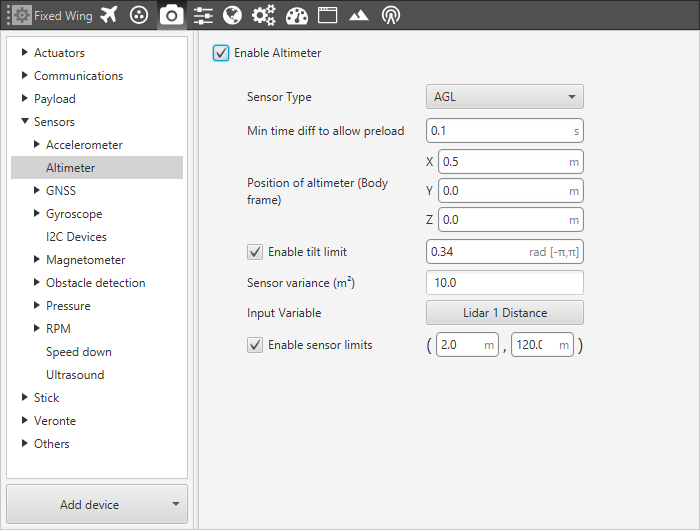
Altimeter Menu - Configuration Parameters
Sensor Type. The system configured in this menu could be used to measure the altitude of the aircraft or to detect the distance from the vehicle to a certain object. This option allows the change between these 2 operation modes
AGL for altitude measurement
Distance for measurement to object detection.
Min time diff to allow preload. Establishes the maximum frequency at which this sensor values will enter the Navigation filter. I.e. if it is executed at 50 Hz and we set (as in the picture 0.1 s) 10 Hz, there will be loops when the value is the one stored before.
Position of altimeter (Body frame). Parameter to indicate the distance from the altimeter to the centre of gravity of the platform. This is used to take into account the weight of the altimeter in the aircraft control.
Enable tilt limit: The altimeter is normally installed in a fixed position having a constant direction with respect to the platform. Taking a LIDAR as an example, it is used to measure altitude so it has to point towards the ground, in a direction parallel to the Z body axis. When the vehicle is not level on its X or Y axis (has a pitch or roll angle different from zero), the LIDAR will not point in a direction perpendicular to the ground, and the measurement taken will not be the real altitude of the aircraft. This option is a safe condition to discard the measure of an altimeter when its tilt angle exceeds a certain value.
Sensor variance. It is a measurement related to sensor error, whose units are squared meters. It indicates the weight that this measure will have in the sensor fusion algorithm that combines the information of different sensors to generate an altitude estimation. For example, if the altimeter installed is a LIDAR, whose precision is quite high, the value of sensor variance has to be low. Actually, the value of the sensor variance is fixed and depends on each sensor, commonly a LIDAR has an error of 0.5 meters more or less, so the variance will be 0.25. Now it depends on the application if the user wants to put this value or a higher one, that will imply that the altitude information depends not almost only on the LIDAR reading.
Input Variable. User chooses the variable in which the sensor data is stored to be processed by Veronte Pipe. There are 5 Lider variables in case it is configured.
Enable sensor limits. It is the range in which the sensor measurement is taken to be processed by Veronte Pipe. Any outer value will be discarded by the system.
The following figure shows a diagram with the values of maximum and minimum sensor limits altitude, and the maximum tilt angle.
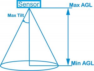
Altimeter Menu - Sensor Limits
For configuring a Lidar, go to Examples - Lidar Integration.