VTOL
VTOL guidance (vertical take-off and landing) is used in multicopters for the take-off and landing operations. This guidance consists on the creation of a vertical line that starts at the point where the platform enters in this guidance.

VTOL Guidance
Set height mode. Height mode indicates how the aircraft will perform the route. Height mode in VTOL guidance is fixed to 3D type. This means that vertical flight is allowed, so both horizontal and vertical guidance have the same priority level.
Arcade position/speed transition In Arcade mode the trajectory generated (position) is not followed and instead the aircraft moves according to the commanded speed. The horizontal and vertical speed parameters serve as the upper-thresholds for when the aircraft’s guidance should be position-based, even in Arcade mode. This parameters are mainly useful for platforms like multicopters.
Set Speed: this option sets the desired aircraft speed during the manoeuvre.
Cruise: sets the velocity modulus of the commanded velocity.
Waypoint reach indicates the speed at which the platform will reach the waypoints of the path, i.e. it will travel along the path with the speed indicated in the option Cruise and then it will decelerate or accelerate to the speed indicated in here.
Defined speed type can be IAS (indicated airspeed) or Ground speed. Normally, IAS is used for airplanes and Ground speed for multicopters.
Deceleration: maximum allowed acceleration/deceleration to meet the desired velocity.
Guidance control: vertical and horizontal PIDs (with constant gains or variable gains based on a schedule or a table) that control this phase. The structure of PID is explained in Blocks.
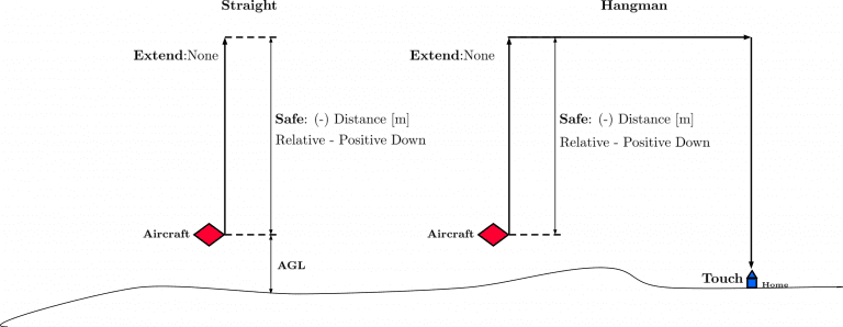
Type: this parameters are used to indicate the route followed by the multicoter during the take-off and landing. The path Straight consists on a vertical line from the point where the vehicle enters in this phase. In the case of a take-off, the line goes from the ground to an altitude indicated by the user. The second option, Hangman, the path consists on a vertical and horizontal line.
Extend: when Up or Down are selected, the value set in Safe will be discard, and the platform will ascend or descend, until a next change.
Safe: this parameter defines the altitude the aircraft reach, it can be Relative (starting from the initial point of the route – current platform position) or an Absolute altitude (MSL,AGL or WGS84). As an example, in a take-off operation, an altitude of -10000 meters can be indicated as the final point of the route, so it is sure that the multicopter will keep climbing until another phase is commended (via automation or manually). The same procedure is done in the landing, indicating a big relative distance (for example 100 meters from the starting point), so it is sure that the vehicle reaches the ground, and an automation is set to stop the platform when it touches the surface.
Touch: additional parameter to be configured when the type Hangman is selected. It defines a point that the aircraft has to reach. For instance, after go Up/Down the value set, the aircraft will perform an horizontal movement according to the point defined. Finally, when the aircraft is over the point, it will descend till reach that point. Usually, this option is used when there are obstacles in the area and by performing this movement the platform can avoid them and land safely.
Note: when the option relative is selected, a positive value will made the aircraft descend. Therefore, this value is Positive down.
The following image gives an overview of some parameters introduced:
Parameters Overview
Guidance-generated Variables
VTOL guidance generates a vertical straight trajectory. It also generates a set of variables which can be used in the control loops. The list of variables is the following:
Desired position.
Track position.
Track state (current patch, last patch).
Desired latitude, desired longitude, desired WGS84, desired MSL, desired AGL.
Desired velocity.
Desired front groundspeed, desired lateral groundspeed, desired velocity down.
Desired tangential acceleration.
Desired IAS.
Guidance north error.
Guidance east error.
Guidance down error.
Desired body velocities.
Desired velocities north, east, down.
Desired heading, FPA and bank.
Route-guidance distance - tangential component.
Route-guidance distance - horizontal component.
Route-guidance distance - perpendicular component.