New Waypoint

New Waypoint Tool
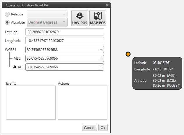
Use the New Waypoint tool and press on the map for creating a waypoint. For moving waypoints, simply drag it to the desired position. If user wants to manually change the coordinates of the waypoint, it is possible to click twice the waypoint and the following display will appear for entering custom parameters. In order to only check them, a resume display can be obtained by simply passing mouse on the point.
Waypoint Settings
There exist two way of defining the position of a waypoint:
Absolute: the coordinates of the waypoint are indicated trough the latitude, longitude and altitude (being possible to define this last one with respect to the ellipsoid, WGS84, to the sea level, MSL or to the ground, AGL). To introduce the point coordinates the user can select 3 and click on the map, introducing later the altitude manually, or press 2 that allows selecting the current position of the air or ground autopilot as the waypoint coordinates.
Relative: in this case, the position of the waypoint is relative to another point. That point could be any platform fitted with a Veronte autopilot. It is possible to select up any waypoint, home or the UAV. It is common to select a waypoint with reference to the position of the ground station. In order to link an object of interest with the position of the ground autopilot please go to section Sniffer.
The other two windows that appear on the waypoint menu are related with the automations of the system. There will appear all the events and actions related with the mission waypoints (Route, Track, Go To), so it is possible to indicate which waypoints will trigger the event or perform the action. To have a deep understanding on the system automations visit Automations.
If you click the right button of the mouse yo can:
Change the name of the waypoint
Remove the waypoint
Set the waypoint as start of the route